Uncle Bud’s Hut Trip
Part 3 – A Walk in the Park to the Top O’ The Rockies
Rogue Carver on the Loose in America
please click the links below
Part 2 – Footloose in the Land of Giants
Part 4 – Nature Pops a Parting Light Show

A Tale of Two Day Hikes, Day 2
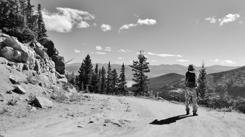
In deciding exactly which terrain to cover on our second day the strenuous exertions of the previous day’s ascent of 12,800 ft Mt. Galena played heavily in my decision, not to say my legs, heels, feet, and anything else that assumed a significant role in the day’s activities. Consequently when the idea struck me to tackle what amounted to a stroll in the park (in comparison) by rambling along a wide open and relatively smooth, even-surfaced wagon track… the notion, shall we say, held an immediate and strong appeal.

Having made an impressively early start from the hut Joseph and I took to the car and within 30 minutes had positioned ourselves at a point where the road finally dissolved into raw riverbed, at which point we parked up, posed for a few selfies (as there was not a soul around for us to ask to take our picture) and prepared ourselves for the hike.

Strangely enough however, after less than a quarter of a mile of the rough riverbed stuff the road suddenly came to its senses and smoothed out… still rough in places but nothing the Infinity couldn’t have taken in its stride.
The old wagon road however proved a real pleasure to hike. How different a road looks when hiked as opposed to driven, and how glad we were that we were walking rather than driving or being driven.
Constructed as a fail-safe against the potential of financial ruin, should a collapse of the the Midland Railroad’s tunnel under the Continental Divide close the line for an extended period of time, the road was constructed to the railroad’s own exacting engineering standards. Such was the company’s concerns fearing a collapse or blockage of the long vulnerable tunnel that they went to the extraordinary length of creating this marvelous alternative route… so that if push came to shove they could ferry people and freight over and around the incapacitated tunnel.
I’m not sure whether they ever needed to use the road in earnest but as a hiking path it proved to be a joy to hike, with breathtaking views in every direction, all the while maintaining a steady but quite undemanding pace.

In contrast to the previous day’s exertions strolling the broad, graded wagon track more resembled a walk in the park than a hike to the top of the world.

~~~

~~~

~~~

~~~

~~~

~~~

~~~

~~~

~~~

~~~

~~~


Unbeknown to either of us, awaiting us at the summit? A spanking brand new sign (not a single bullet hole to be seen) demarking the actual spot on which water will ultimately be sent packing into either Pacific or Atlantic oceans. Of course we are all well aware that the mighty Colorado no longer makes regular contact with its prescribed ocean, but at least this sign will serve to remind us that it would be a good idea if one day in the not too distant future it once again will.

~~~

~~~
thanks for visiting martincooney.com
~~~
⇑⇑∂ΓτïΠ
~ ∫ •
√